by DriveinMovie.com Released : 2022-05-17
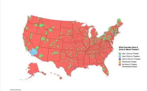
Using drive-in theater location data from the DriveInMovie.com website, Reddit user Peteyy34 created the map shown in this article to show how many open drive-ins each county in the United States still has. Counties with no remaining drive-in theaters are colored red, counties with one drive-in are colored in green, counties with two remaining drive-ins are colored blue and counties with three remaining drive-insare colored purple. (see the key in the map). For a larger version of this map, visit Peteyy34.
The first thing that is apparent is that there simply are not many counties remaining with drive-in theaters. The map is mainly red. And that makes perfect sense given the fact that there are about 3000 counties in the United States and there are only about 330 remaining drive-ins. So that averages about one open drive-in per 10 counties.
So we already knew there were not many drive-in theaters remaining in the U.S. But to illustrate how much the drive-in industry has shrunk, lets compare today's figures with the height of the drive-in era which occurred during the late 1950's and early 1960's. At that time, there were about 4000 operating drive-ins compared to today's 330 which means more than 90% of drive-in theaters have closed. At the height of drive-in theaters, there would have been on average more than 1 drive-in for every county in the U.S. versus the 1 for every ten counties currently.
Another way to look at it is drive-ins per capita. The current population of the United States is about 330 million people. With 330 currently operating drive-in theaters, that means there is about one open drive-in theater for every one million people in the United States. At the end of the 1950's, there were about 4000 operating drive-ins and the U.S. had a population of about 177 million. That means there would have been about 22 drive-ins for every one million people versus the 1 drive-in per million people today. That is quite a difference.
What is also interesting about the map is that it shows a concentration of drive-ins in the Midwest and Northeast. When you look at states like Indiana, New York, Pennslyvania and Ohio, you will see many more counties with drive-ins than in other states. In some states there are no remaining drive-ins and in others there are no drive-in options in large areas of the state.
If you want to dive deeper and look at individual drive-ins by state and location, you can use our interactive map of drive-ins in the United States which allows you to zoom into different areas on the map to see each drive-in. To use, it follow this link: Interactive Map of Drive-ins.
If you love drive-ins and want to help support them as well as stay up to date on drive-in news, please visit and Like our Facebook page at www.facebook.com/driveinmoviepage/.